There is a popular myth taught to school children (which most adults today still believe) that people in history have travelled in perfectly straight lines Eastwards or Westwards and eventually arrived back at their starting point. It is heralded as proof of the globe Earth, and claimed that hundreds of adventurers since Magellan have completed such successful circumnavigations, but the truth is that no one in history has ever set off travelling in a perfectly straight line and returned back at their starting point. All successful circumnavigations in history, whether by sea or air, have instead followed the same pattern, which is sailing or flying the most convenient route from port to port stopping for supplies and re-fueling until a complete circle has been made. Not a single sailor or aviator in history has (or could) travel only in the same one perfectly straight direction and magically arrive back where they began. This ridiculous lie becomes obvious when critically examined, but when taught to young children successfully bends and warps their minds into accepting globe indoctrination.
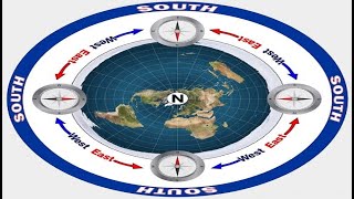
Unlike the cardinal directions on a compass rose, North, South, East, and West on Earth are not simply straight lines separated by 90 degrees. North, rather than being an upward shooting arrow, is actually a point – a centerpoint – THE centerpoint of the entire Earth known as the geographic North Pole situated directly below Polaris, the North Pole star, the only motionless star in the heavens which marks the exact Northern centerpoint of the sky. South, rather than being a downward shooting arrow, is actually every line tangent to the Northern centerpoint, or in other words, every straight line extending outwards from the North Pole heads due South. East and West, rather than being right and left facing arrows, are actually clockwise and counter-clockwise circles around the Pole. The Sun, Moon and stars all rise in the East and set in the West, making perfect circles over and around us every day. As you can observe, they travel in a circular Westwards path over and around the Earth, and do not all travel in a straight leftward direction as suggested by a compass rose. Likewise navigators since ancient times have used Polaris to guide their ships, knowing that Polaris was the heavenly North Pole, South was traveling keeping your back to Polaris, East meant traveling keeping your left shoulder 90 degrees to the Pole Star, and West meant traveling keeping your right shoulder 90 degrees to the Pole Star.
All circumnavigations in history have been Eastwards or Westwards and never Northwards or Southwards because the latter is geographically impossible. Likewise Southern hemisphere flights from Australia to South America, or New Zealand to South Africa, for example, never fly the shortest, most direct route on a globe which would be Southwards over Antarctica. It is claimed this is because such flights would allegedly be too cold for any airplanes to handle, but the reality is the routes are geographically impossible because Antarctica is not a tiny ice-continent confined to the underside of a spherical spinning ball-Earth. Antarctica is actually the outer Southern perimeter of our level motionless plane Earth and surrounds the other six continents. How far Southwards Antarctica actually extends and how it terminates or what exists beyond it are all unknown to and kept from the general public however, and as a result, no completely accurate, fully functioning flat Earth map exists or could exist without the people being first allowed full independent exploration of the Arctic, Antarctic, and every where else.
There are, however, several maps which work as good visual aids for approximating the geography of our flat, stationary Earth. The Gleason’s 1892 new standard map of the world and Hammond’s 1945 air-age map of the world are two such maps. These so-called « Azimuthal Equidistant » maps are used in practical navigation and can be found in the logos of the United Nations, World Health Organization, International Maritime Organization, and International Civil Aviation Organization. They purport these to be simply two-dimensional representations of a spherical Earth with the North Pole at the centerpoint and claim these maps were made by flattening the globe, but just the opposite is true, and the globe (specifically the so-called « continent » of Antarctica) was made by spherizing our flat Earth, and bundling the expansive outer perimeter into a cramped oddly shaped ice-continent under the ball, kept off-limits by treaty from the general public.
To learn more about our level motionless Earth, please visit:
http://www.EricDubay.com
http://www.AtlanteanConspiracy.com
http://www.IFERS.123.st